The History of Braslav
55°38'N, 27°02'E
Lakes, Borders and Turmoil - The History of Braslav
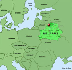
Braslav is a small town in the Vitebsk district of north-eastern Belarus, some 250 kilometres from Minsk, the capital of Belarus. Under Russian rule, up until World War I, Braslav had been part of the Novo Aleksandrovsk (Zarasai) Uyezd (district) in the Kovno Gubernia. Later, under Polish rule, Braslav became the district capital within in the Voivodeship (province) of Vilna some kilometres south-west of Braslav. With all these border changes it will be of no surprise to learn that the town received many names - Braslav - in Russian; Braslaw in Polish, Braslau - in Belarusian, Breslauja in Lithuanian, Braslau in Latvian and Breslev - áøòñìàåå in Yiddish.
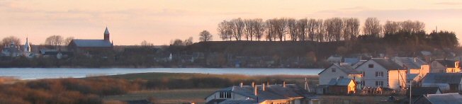
Braslav's landscape of rolling hills, forests and over thirty lakes connected by streams and rivers is known for its natural beauty. The picturesque character of the region led Belarus to declare the area as the Braslav Lakes National Park in 1995. The topography was shaped by the glacial action of the Ice Age which left a relief of moraine hills and hollows, that later filled with water. The largest of the moraine hills is found at Slobodka, between the Niedrava and Potekh lakes. The National Park supports a rich variety of flora and fauna, including European bison, wild boars, roe deer, marten and mink. The lakes are well known for their abundant fish, especially bream, pike, carp and eels.
Poland
Lithuania
Ukraine
Latvia
Russia


Belarus
| Year |
Population |
Jews |
% |
| 1700 |
|
3 |
|
| 1766 |
|
225 |
|
| 1790 |
|
89 |
|
| 1836 |
2000 |
|
|
| 1847 |
|
591 |
|
| 1897 |
1501 |
1234 |
82 |
| 1921 |
1587 |
1130 |
71 |
| 1925 |
2600 |
1900 |
73 |
| 1989 |
14000 |
17 |
0.12 |
The Population of Braslav
Braslav - a Troubled History
Braslav is first noted in the eleventh century, some 300 years prior to the founding of Vilna. Under the auspices of the Duchy of Polotsk (Potocki), the region was located in the border area between Muscovite Russia, Poland and Lithuania. First known as Bryachislav (Braczislaw) the town was named for Bryachislav Izyaslavich (997 - 1044), the reigning duke of Polotsk and nephew of Yaroslav the Wise, . As a border town the location was a strategic choice. Thus the town was set between protective lakes, low hills, swamps and forests. Furthermore, the proximity of the river Dvina provided direct transport connections from the interior out to the Baltic, helping to improve the town's economic condition. With the unification of Poland and Lithuania in the Jagiellon period at the beginning of the fifteenth century, Braslav was placed under the Vilna Gubernia (governate), the administrative capital of one of the five sub-districts (uyezd). To differentiate it from the Braslav near Uman in Ukraine, official documentation refers to the settlement as 'Braslaw of Lithuania'.
In 1500 Braslav received patial Magdeburg rights and was given to Helena, daughter of Ivan the Great and wife of Alexander Jagiellon the King of Poland and the Grand Duke of Lithuania. Even with a marriage alliance this period was one of repeated border conflict between Muscovite Russia and Poland. A description of 1554 notes the castle, five streets, 110 houses and thirty shops, but cross border fighting, raids and fires caused damage to the town, especially resulting from the short Tartar conquest of Braslav during which heavy tribute was exacted from the residents.
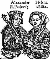
Yaroslav the Wise Alexander & Helena
If this was not enough, flooding in the 17th century devastated the town. Consequently the authorities in Warsaw exempted the inhabitants from tax for a period of four years. Like all provincial areas under the Polish monarch, Braslav was controlled by the local feudal
nobleman (szlachta or poretz). Initially Braslav was controlled by the powerful Sapieha family, through with time it would change hands many times from one szlachta to the other.
At the center of Braslav, on a hill (Gory Zamkovaya) set between the large Dryviata (Driviati) Lake and the smaller Noviata (Noviato) Lake, was the citadel, which housed a prison, a monastery and a church named for the Mother of God. The garrisons who moved through the town were barracked there. The strategic advantages of "Schloss Barg" were recognised by King Stanislaw-August, the last King and Grand Duke of the Polish-Lithuanian Commonwealth who gave Braslav its coat of arms - a radiant triangle surrounding the eye of providence (Oko Opatrznosci in Polish) in 1794.
Sapieha
Coat of Arms
King Stanislaw August
Braslav's Eye of Providence
Map of 17th Century
Excavation on Castle Hill
Braslav in the Middle Ages
Memorial to Founding of Braslav
Following the second division of the Polish-Lithuanian Kingdom in 1783 Braslav was annexed to Russia, remaining under Czarist control till the twentieth century. Between the 18th to 21st July 1812 the countryside around Braslav hosted the Russian and Napoleonic armies as they passed through prior to the battle for Moscow and the subsequent retreat of the French Army.
During the years of the nineteenth century Braslav was mainly a Jewish town within the Pale of Settlement, though along side lived Poles, Latvians, Lithuanians, Germans and Belorussians.
The First World War brought the area under German occupation for three years (1915-1918) and with the end of the war the Vilna Gurbernia was passed back to the Poles only to be taken by the Bolsheviks in 1920 and then returned to Poland. In 1922 the town was formally annexed to Poland, becoming a district capital within in the Voivodeship (province) of Vilna
The Russo-Napoleonic War of 1812 - Troops Movements through Braslav
Braslav in the Twentieth Century
Although nothing remained of the citadel on Castle Hill (Schloss Barg), the hill dominated the centre of Braslav, the houses scattered around its base. Running through the centre of the town was the main street, known by the Jews as 'die groisse gass'. Under Polish rule from 1918 the same street would be named for the Head of State - Jozef Pilsudski, and then for Lenin under the Soviets. The cobbled street was flanked by wooden pavements that shook under step. Along the street were houses, set on stone foundations, faced with weather beaten planks and painted doors and windows.
Between the houses were a variety of shops selling goods for the townspeople and for the peasants from the surrounding villages - groceries, saddles, cloths, shoes, and other wares. The street intersected with the Third of May Street, named for the constitution of Poland. Along this street, on the side of the hill was the red brick Catholic Church dedicated to the Birth of the Blessed Virgin Mary. The church originally established in 1424 was rebuilt in 1897. On the other side, beside the bank of Lake Dryviata, stood the nineteenth century white and blue Russian Orthodox Church of the Assumption, roofed with five onion domes. Each day the bells of the two churches competed to gather the faithful to prayer.
") | Map of Braslav (Slobodka at top right) |
|
 | Pilsudski Gass |
|
 | Church and Dryviata Lake |
|
 | View of Braslav |
|
 | View from Castle Hill |
|
 | The Catholic Church |
|
 | Braslav in 1915 |
|
Close by was the synagogue court containing three synagogues, two of the Chasidic tradition and one Beth Midrash associated with the Mitnagdim. In the same courtyard was the large building of the fire-brigade, a central institution of any wooden shtetl and mostly manned by Jewish volunteers. Inside the building were bright red wooden barrels on wheels, hand pumps, brass pipes, hatchets, firemen's poles, and other implements. The firemen, all volunteers, are almost all Jews, mostly middle-aged, broad shouldered, sturdy, many of them sporting beards. On the sounding of the bugle and alarm bells the volunteer firemen would rush to the station - pick up their buckets, hatchets and picks, hitch the horses to the wagons on which the barrels and pumps were loaded and hurry to the fire. Often bucket chains were formed from the burning house directly to the lake. The firemen also formed a brass band that entertained the residents during festivals and public occasions.
Catholic Church of the Birth of the Virgin Mary
Russian Orthodox Church of the Assumption
Further up, on the side of the hill was the Chasidic Sandy Minyan and still beyond that the flour mill belonging to the miller Byk and the electricity power station.
Lake Dryviata, sustained a variety of fish species. With winter the lake was covered by a sheet of ice. At night fishermen, lanterns in hand, took pikes and broke blow holes in the ice. Nets and hooks were dropped through the holes and the fish attracted to the light could be hauled up. In the summer the lakes were also places of recreation. On balmy summer nights children would frolic in the water, though the life giving lake would also claim drowning victims, plunging the town into mourning.
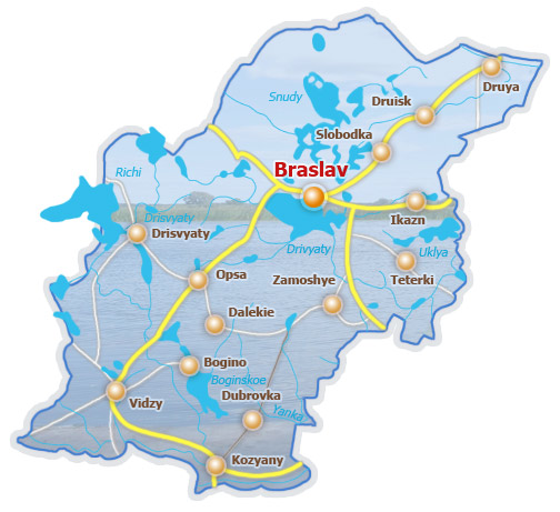
To the west, the 'die grosse gass' lead to the 180 kilometre dirt road to Vilna through smaller shtetls, forests and past the country estates of the szlachta. North of the same street the lanes were blocked by the narrow gauge railway and the station located beside the Christian neighbourhood of Gumnes. From there the train led north alongside the lake to Slobodka and on to Druya, where transfer to the main line railway on to Warsaw through Latvia was possible.
Side streets led to the marketplace, the post office, and the Magat brothers printing works that published a weekly newspaper featuring local and regional news.
The Braslav Fire Brigade and Band
BRASLAV
Lake Noviata
Lake Dryviata
1
2
3
6
7
11
5
12
4
9
8
10
14
13
Braslav until June 1942
1 Ghetto
2 Orthodox Church
3 Catholic Church
4 Castle Hill
5 Old Synagogue
6 Hospital
7 Yavneh school
8 Rolnick Co-op shop
9 Jewish Cemetery
10 Christian Cemetery
11 District Admistration
12 New Synagogue
13 Folkschule
14 Death Pits?
15 - Byk Flour Mill
15
Beyond the Jewish cemetery was the well appointed suburb inhabited by Polish government officials and intelligentsia and also in which local government institutions and the courthouse were located after the provincial government in Vilna established its district headquarters in Braslav. The government architect, J. Klos, designed a series of residential dwellings for the Polish officials and in 1929 a large white building was constructed for the district administration. On the suburbs edge was the Karpowicz forest, well known for its scenic walks, but shunned by the Jews because of its proximity to the Polish suburb. The Jews preferred the Dubkes forest at the opposite end of the shtetl. After Nazi occupation the same forest provided some shelter and partisans operated from there.
Recreation on the Lake
The Byk Flour Mill
Magat Printing Workers
Doctor Narbutt and his Hospital
Braslav District Headquarters
Christian Parades
On the summit of Castle Hill was a tall white monument to the memory of Dr. Stanislav Narbutt. Capping the monument is a lantern used to warn fisherman on the lakes of an approaching storm.
Dr. Narbutt was a Braslav community leader and doctor at the beginning of the twentieth century. Fluent in Yiddish, he was much loved by all sections of Braslav society and in 1906 built a hospital in the town which he managed till his death in 1928. The hospital remained in use until 1994.
The Dr. Narbutt Monument and Hospital
other produce would make their way to the city. On their return trip, they would bring back manufactured goods such as textiles, footwear, sugar, salt, soap, various kinds of oils and hardware. During summer months sleighs were replaced by the trucks owned by the Milutin and Bielak families.
Houses Built for Polish Government Officials
The Market, Trade and Commerce
The marketplace was not situated in a central square but situated in a back street, in a space surrounded by houses. Twice a week, on Wednesday and Friday, peasants from the villages would load there carts and make their way to Braslav to sell their produce - potatoes, fruit, vegetables, hay and oats, chickens, hides, hog's bristle for brushes and firewood. Peasants and Jews, with family connections beyond the nearby border with Latvia would also bring smuggled goods for sale, in particular sugar, the price of which was regulated by the Polish government. The peasants used to hide a few sacks of sugar in a wagon loaded with hay and sell it to the local shopkeepers. Jewish peddlers were also a common feature of the market selling cheap clothing, cloth and fancy goods.
Vilna, the closest large city inside the Polish borders between the wars, was around 180 kilometres distant. Braslav only had a narrow gauge railway that did not connect directly to the main line to Vilna. It was deemed more efficient and economical to dispatch goods by other means. Especially during the winter months, after the roads had frozen, horse drawn sleighs loaded with fish, meat, poultry, eggs, flax, hides, and
The star market attraction was the so-called 'zadarmenikes' (givers-away). Their cries of It's a give-away, give-away earned them this nickname. Amid the hubbub, the creaking of wheels, the shouts and curses of drunks, the hoarse cracked voice of the crier, usually an emaciated young man, would rise. Poised high on his wagon, he'd proclaim and extol his cheap almost worthless merchandise: combs, scarves, penknives, and other knickknacks. Crowds, mostly peasants, would flock, jostle and push - all eager for bargains.
Zadarmenikes
Fresh fruit played a part in the economy with families spending the summer and early autumn guarding the orchards, picking the apples and pears and selling them in Braslav and beyond. Many Jews worked as tradesmen, artisans and journeymen as tailors, cobblers, tanners, milliners, watchmakers, carpenters, locksmiths, tinsmiths, rope makers, bakers and so on. Still many Jews and gentiles were unskilled workers who barely eked out a living. The poor supplemented their income by cultivating a small kitchen garden and keeping a cow, a goat, a few chickens, or geese. The few well paid government clerical positions in the Braslaw District administration were open only to middle class gentiles, many of whom came from outside the town.
Starovery - The Old Believers
the ice. Most of the fishermen themselves were Starovery, members of the old faith sect of orthodoxy.
Surrounding Braslav were a series of villages or shtetlach. Slobodka was one of them and will be described separately. For example the train from Braslav led through the forests for eighteen kilometers to Dubene. Its mostly Jewish population, numbering less then one hundred families, engaged mainly in agriculture. Each family owned its own plot where it kept horses, cows, sheep, geese and chickens and cultivated a vegetable garden, fruit trees and flowers. There was the usual sprinkling of shops, the ubiquitous artisans, especially itinerant tailors who eked out a living from the nearby peasants. In 1927, a cooperative dairy was established in Dubene for the manufacture of butter and Dutch cheese. Dubene, like most adjacent Jewish villages, was closely linked with Braslav through commerce, administrative affairs, education and ties of blood. And adjacent to Dubene was Okmienic, a village with only one Jewish family. And then there was Jaisi, Drujsk, Plussy, Opsa and so on and so forth.
Schneor Aharon
However, Braslav's central industry was fishing, and fish were processed at the plant owned by Schneor Aharon, who having the state concession became one of its richest men. Entire families were engaged in buying, reselling, transporting and packing the fish. The main fishing season was winter during which 'windows' were cut in the ice, nets lowered through the holes, and fish hauled up through
Braslav's fishermen belonged to the old offshoot of the Orthodox church, the 'Starovery' (i.e. members of the old faith). They were tall, well-built, powerful men with bushy beards who would come once a year, and flock to Braslav to celebrate the festival 'Grornica' (Candlemas). Candlemas, the day on which the church candles are blessed, was celebrated on February 2nd, the Feast of the Purification of the Virgin Mary, and the presentation of Christ in the Temple after his circumcision. This festival, with its pageantry and carnival air, almost invariably coincided with Purim. The men would come mounted upon beautifully decorated sleighs drawn by magnificent horses, with jingling bells and festooned with colored ribbons. They would spill out and stroll about the streets, their women dressed in all their finery, bedecked with jewels. While strolling, suddenly without warning, a young man would drive up with fury, grab a maiden and drive off with her to an unknown destination. A few days later he'd send matchmakers to her parents, as this was no kidnap as all had been agreed upon beforehand. In the afternoons the Starovery would hold horse races on the snow-blanketed frozen lakes, to the delight of the entire shtetl.
The Jews of Braslav - (a more detailed description can be found here)
Jews had lived in Braslav since the 16th century, adopting typical professions of the Pale of Settlement. With time the Jewish population grew, especially as a result on restrictions place on Jews in the rural areas which concentrated their occupancy to the small towns. By the nineteenth century Jews formed the majority of Braslavs population organised into a self-sufficient community providing religious, educational and social services. The Jews were also involved in the wider society. Many were politically and culturally involved and many enlisted into the Czarist army and later to the Polish military. Still anti-Semitism was rife, resulting in the formation of self-defense groups, notably during periods of political instability.
The Ribbentrop-Molotov pact tore Poland into two in 1939 with Braslav falling under the Soviet sphere. Though Jewish activities were restricted life was to change for the worse with the Nazi-German conquest during Operation Barbarossa in June 1941. Soon anti-Jewish measures were put in place leading to the liquidation of Braslavs Jewish community in June 1942 and again in March 1943. The survival rate was minuscule, though some were hidden by righteous gentiles will others fought from the surrounding forests as part of the partisan resistance.
After the War
The Soviets reentered Braslav in the summer of 1944. The few who returned were not welcomed by the gentiles who had taken Jewish property. Furthermore, as a result of the Teheran Conference of 1943, Soviet post-war policy included large scale redefination of the eastern border of the Soviet Union. As a consequence the Polish population was moved out of the eastern provinces (Kresy) of pre-war Poland to the areas west of the Curzon Line. The surviving Jews, who had been Polish citizens in the interbellum, were transferred together with the Poles. Many found their way to new lives in the newly established State of Israel. Belarusians filled the space left by the Poles and Braslav grew, though remained rural and lacking in industry.
Even prior to the war the beauty of the lakes of the Braslav area were well known in Poland. For this reason the town had been chosen by the Polish state to provide a home for the Central Institute for Sport and was used as a centre for the training of Poland's elite sportsmen, especially water sports. The special character of the region and biodiversity was recognised by the nascent Belarussian state after its independence and in 1995 the area was declared as a National Park with centres in Braslav and Slobodka.
Views of Braslav
Braslav - Then and Now
The Orthodox and Catholic Churches of Braslav
Die Grosse Gass - Pilsudski Street before WWII became Lenin Street Today
Buildings - Pre-War and Modern (The red brick building above housed the Nazi Gendarmerie during the War, now the Post Office)
Wooden Statues on Castle Hill
Statue of Lenin beside District Administration Building Memorial to the Fallen Soldiers of the Great Patriotic War
Aerial Photographs of Braslav and the Lakes
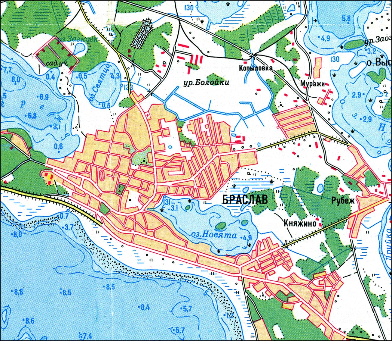
Maps of the Braslav Region
Regional Maps of Braslav in 17th Century and as a district of the Polish Province (Voivodeship) of Vilna in the Interbellum
Sources
This article is based on secondary unreferenced research. Most of the bibliographical material available is written in Polish, Russian and Belarusian, languages in which I am not proficient. Please feel welcome to contact if you wish to correct or augment the information.
1 - Emesh Shoah - Darkness and Desolation, In Memory of the Communities of Braslaw, Dubene, Jaisi, Jod, Kislowszczizna, Okmienic, Opsa, Plusy, Rimszan, Slobodka, Zamosz, Zaracz; 1986; eds. Machnes Ariel, Klinov, Rina; Ghetto Fighters House. (Hebrew with English and Yiddish summary).
2 - Braslav. In. Pinkas Hakehilot: Poland, Vol.8 - Vilna, Bialystok and Nowogrodek Districts. Shmuel Spector. Ed. Yad Vashem. Jerusalem. 2005. Pp. 191-195 (Hebrew).
3 - The Internet sites linked throughout the text.
Recent Maps of Braslav District of Belarus
Copyright © 2008 Jon Seligman. All Rights Reserved.