|


Copyright © 2015 Jon Seligman. All Rights Reserved.
The 2015 Ground Penetrating Radar (GPR) Survey


A RESEARCH, EXCAVATION, PRESERVATION AND MEMORIAL PROJECT

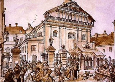
During the week of the 22nd to the 26nd of June 2015 the first season of project work was conducted at the site of the Great Synagogue and Shulhoyf of Vilna (Vilnius). This season of work at the site was devoted to a Ground Penetrating Radar (GPR) survey of the site of the Great Synagogue and Shulhoyf of Vilna to gauge the exact positioning of the underground remains and to better understand the archaeological potential of the site prior to the future investment of further resources to fully uncover the remains through excavation.
This season of work was sponsored by members of the team itself, aided by a generous grant from the Commission for the Preservation of America's Heritage Abroad of the US State Department. Commissioner.Dr. Joan Silber not only helped the project through the provision of a grant, but also personally documented its progress with photographs and video.
The participating team this year were:
Dr. Jon Seligman of the Israel Antiquities Authority
Zenonas Baubonis and Manatas Daubaras of the Kulturos paveldo išsaugojimo pajegos (Culture Heritage Conservation Authority of Lithuania)
Prof. Prof. Richard Freund and Nicole Awad of the Maurice Greenberg Center for Judaic Studies, University of Hartford
Prof. Harry Jol and Alexis Pingel of the University of Wisconsin, Eau Claire
Prof. Philip Reeder of Duquesne University
Dr. Vladimir Levin of the Centre for Jewish Art, Hebrew University of Jerusalem
Dr. Joan Silber of the Commission for the Preservation of America's Heritage Abroad
A few words concerning the methodology of GPR are added here before discussing the results of the survey in Vilnius.
What is Ground Penetrating Radar?
Ground Penetrating Radar (GPR) is a tool that allows archaeologists and geoscientists to work together to map an area that they think might yield important finds and explore the sub-surface without disturbing the site. This non-invasive, non-destructive survey allows the researcher to assess and prioritise future work that could be explored through more invasive means: coring, sampling, small archaeological probes and long term excavation. Based on data that is collected, GPS locations can be pinpointed on the site maps so that future excavations can be extremely precise and planned with great care; especially in areas where there are identified artifacts of singular importance. This methodology can save money, time, and human resources in modern archaeological digs but it also insures that an excavation is planned with attention to the priorities of exigency (salvage) and/or in the case where possible human remains are located to insure that provisions are made in advance.
Before GPR, archaeologists would excavate with little knowledge of what they might find below the surface. The way that the GPR system works is by sending high frequency electromagnetic waves (similar to FM radio signals) into the subsurface through antenna. These waves reflect back off changes in the materials / layers below surface and are received by a second antenna. As the data is collected in the field and stored on a computer, an image of the soils underneath can be seen. With the data stored, post-processing after leaving the site can allow one to extract details of the structure of the subsurface through 2D and 3D visualisations. These 2D and 3D images or maps of the subsurface contain various patterns that are interpreted.
Before GPR, archaeologists would excavate with little knowledge of what they might find below the surface. The way that the GPR system works is by sending high frequency electromagnetic waves (similar to FM radio signals) into the subsurface through antenna. These waves reflect back off changes in the materials / layers below surface and are received by a second antenna. As the data is collected in the field and stored on a computer, an image of the soils underneath can be seen. With the data stored, post-processing after leaving the site can allow one to extract details of the structure of the subsurface through 2D and 3D visualisations. These 2D and 3D images or maps of the subsurface contain various patterns that are interpreted.
The Great Synagogue of Vilnius (Vilna) is an excellent target because the GPR system works well when a well-defined area can be worked on and plotted on an existing footprint guided by the research questions stated at the outset and the physical constraints dictated by the site.
It is proposed to cover three separate areas of the site. In 2015 the GPR survey was concentrated to the immediate area of the destroyed synagogue (area A in figure below), the aim being to identify the building of the synagogue and of the shulhoyf. Particular attention was given to isolating the remains of the ritual bath (miqve) and the water system, as there is a strong possibility that these areas of the sites are better preserved as they were set below the original floor levels. The other areas to be surveyed with GPR in coming seasons are area B to the north of the synagogue complex and area C to the south, the aim being to outline the structures of the immediate area of the synagogue to connect the complex with the surrounding urban fabric.
It is proposed to cover three separate areas of the site. In 2015 the GPR survey was concentrated to the immediate area of the destroyed synagogue (area A in figure below), the aim being to identify the building of the synagogue and of the shulhoyf. Particular attention was given to isolating the remains of the ritual bath (miqve) and the water system, as there is a strong possibility that these areas of the sites are better preserved as they were set below the original floor levels. The other areas to be surveyed with GPR in coming seasons are area B to the north of the synagogue complex and area C to the south, the aim being to outline the structures of the immediate area of the synagogue to connect the complex with the surrounding urban fabric.
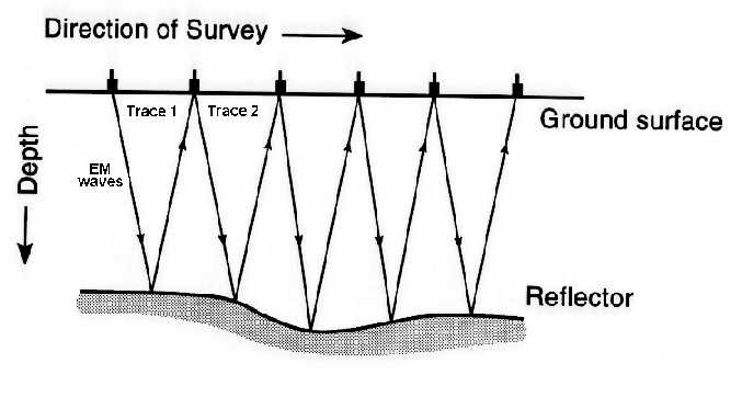
Illustration of GPR technique
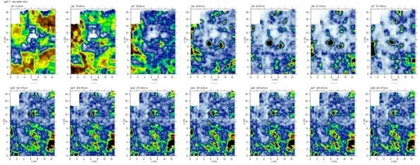
For the GPR survey of the Great Synagogue of Vilna, Professor Harry Jol of the University of Wisconsin at Eau Claire used a pulseEKKO 1000 GPR system and 225 MHz antennae. The backpack carries the console and computer to allow for portability while the second individual pulls the antennae along the ground surface, the wheel triggering the system to send electromagnetic (radio) signals into the subsurface. After the waves have been returned, the computer receives the echo in real time, compiles the data and displays it on the screen. By looking at the readings one can detect anomalies present in areas beneath the surface. Based on the clustering of these anomalies a higher resolution survey with a tighter grid and a 450 MHz antennae can be used to collate more detailed data.
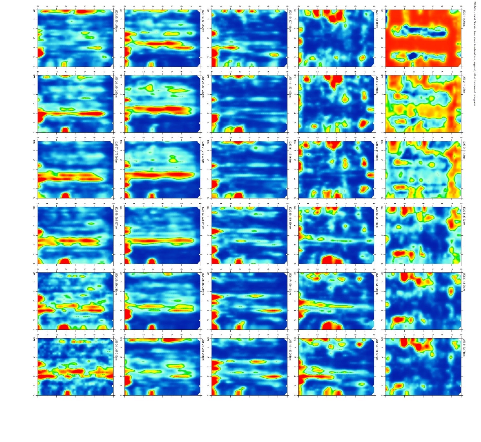
The raw data was transferred to Dr. Dean Goodman, a Geophysicist of GPR-SLICE Software and the Geophysical Archaeometry Laboratory in California, USA, who processed the data with 2D/3D time slices, isosurface and overlay analysis and provided 3D models and animations. The time slices can be used to assist in determining the most likely areas to yield useful excavations.
The raw data was transferred to Dr. Dean Goodman, a Geophysicist of GPR-SLICE Software and the Geophysical Archaeometry Laboratory in California, USA, who processed the data with 2D/3D time slices, isosurface and overlay analysis and provided 3D models and animations. The time slices can be used to assist in determining the most likely areas to yield useful excavations.
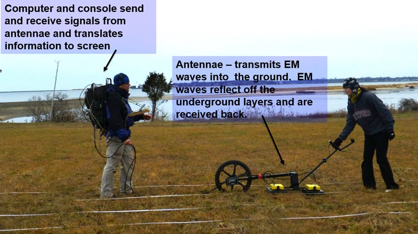
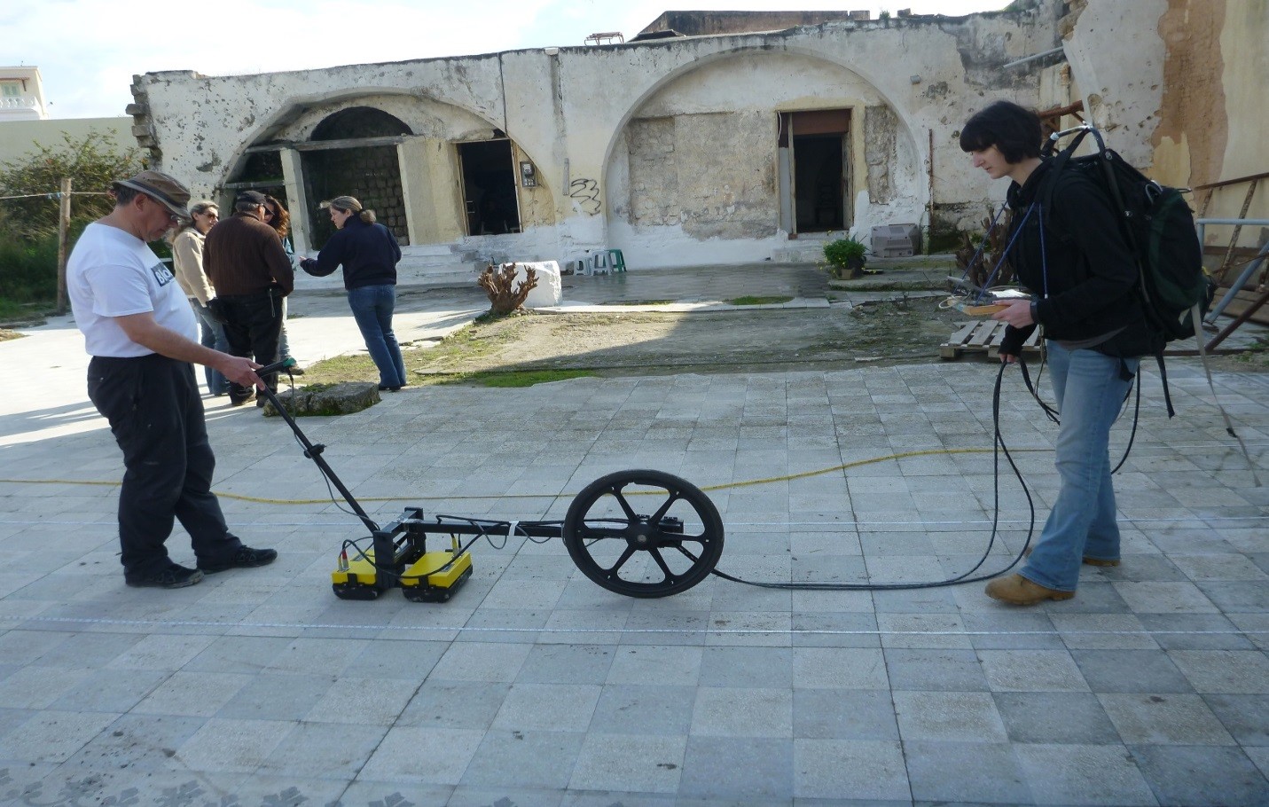
Prof. Harry Jol Working in the Field with a a pulseEKKO GPR System
Previously Prof. Jol, together with Prof. Richard Freund and Prof. Philip Reeder conducted similar research at other sites with potential for gathering data from a GPR survey in an archaeological context. Data sets collated and analysed with GPR technology were used to pin-point locations at archaeological sites for further research and excavation so that all of the areas do not have to be disturbed. Recently a three dimensional survey in Nazareth at the Church of the Annunciation (Greek Orthodox) in Israel provided data of an ancient Church at the site. Similarly in Rhodes, Greece, a survey of the 16th century Kahal Gadol Synagogue, also destroyed by the Nazis in World War II, will enable local archaeological authorities to comprehend possibilities for excavation and restoration with a full knowledge of the sub-surface and earlier iterations of the synagogue built on the same spot. Other work includes a GPR survey of the Extermination Camp at Sobibor in Poland, where the GPR survey was used to better understand the layout of the camp that was dismantled in 1943.
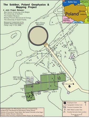
GPR Survey Projects at the Kahal Gadol Synagogue in Rhodes & at the Sobibor Nazi Extermination Camp in Poland
The Ground Penetrating Radar Survey at the Great Synagogue of Vilna (Vilnius), 2015
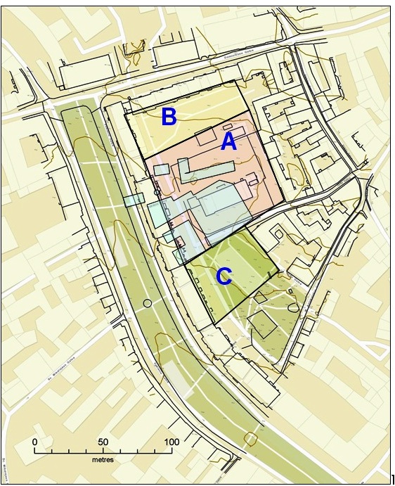
GPR Survey Areas of the Great Synagogue and Shulhoyf of Vilna (Vilnius)
Area A (pink overlay): Area above the structures of the Great Synagogue & the surrounding courtyards & buildings - 5700 square metres (excluding standing school building).
Area B (yellow overlay): Area to north of Great Synagogue - 2400 square metres.
Area C (green overlay): Area south of the Great Synagogue, Ramayles Yeshiva and original Zydu gatve - 2000 square metres.
Structures of the Great Synagogue & surrounding buildings marked in blue overlay.
Area B (yellow overlay): Area to north of Great Synagogue - 2400 square metres.
Area C (green overlay): Area south of the Great Synagogue, Ramayles Yeshiva and original Zydu gatve - 2000 square metres.
Structures of the Great Synagogue & surrounding buildings marked in blue overlay.
GPR Survey Grid from the Shulhoyf
|

|

|

As we noted the goal of the first season of the GPR survey at the site of the Great Synagogue and Shulhoyf of Vilna was devoted to gauging the exact location of underground remains and to better understand the archaeological potential of the site prior to the future investment of further resources to fully uncover the remains through excavation. With the limited available time of only five days it was decided to concentrate on the area A in the plan, an area covering a major portion the synagogue and shulhoyf.
The first area surveyed was the space west of the school building, up to the line of trees along Žydu Street. To provide a control two grids we set up to by connecting up to the known results of the 2011 excavation at the site conducted by Zenonas Baubonis. While a full report of the GPR survey is still forthcoming, initial results indicated clear matching between those of both the 2011 excavation and the plan of the synagogue with the GPR survey results. Especially clear in the scans were the interior and exterior wall, the Bimah and the Aron Kodesh (Torah Ark).
The second area surveyed in 2015 was east of the school building, covering areas that according the plan of the Shulhoyf, should included the Miqve complex, the Old Kloyz, the Yesod Kloyz and the back section of the Great Synagogue. The results of this survey are still being analysed, but initial impressions are positive, including what may well be the miqve and the synagogue walls. The importance of this result, if correct, cannot be underestimated and it will surely govern our decisions concerning where to excavate in coming seasons.
As soon as analysed results of the GPR survey are received, they will be published here.
Scenes of the 2015 GPR survey in Vilnius at the site of the Great Synagogue and Shulhoyf of Vilna


[The Project] [Community] [Partners] [The Team] [The Synagogue] [The Vilna Gaon] [Previous Work] [Media] [Links]